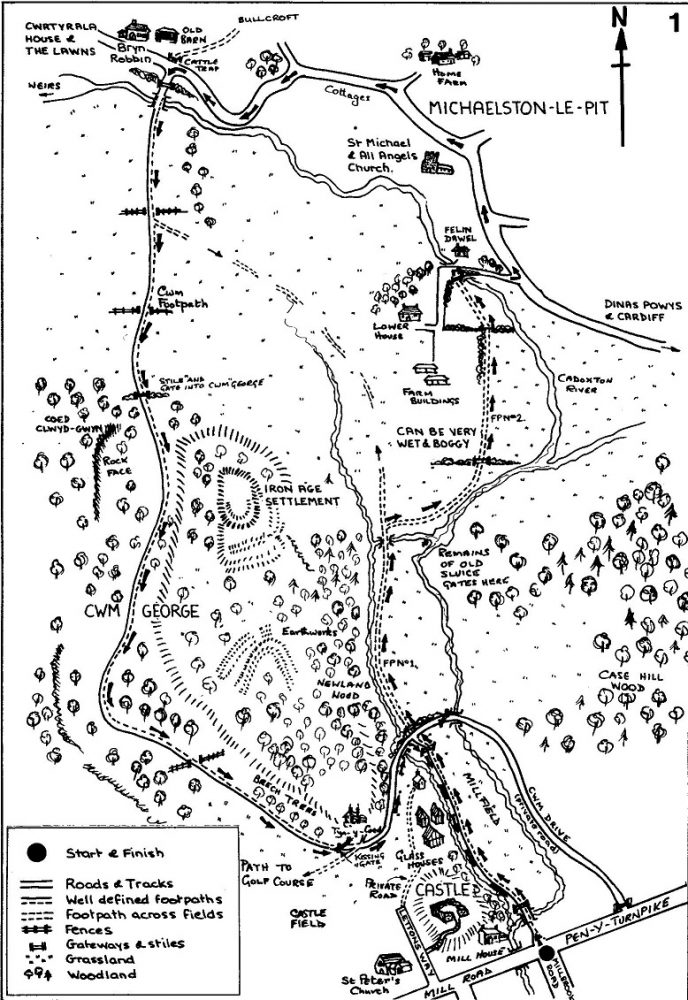
Michaelston-le-Pit and Cwrtyrala Basin returning via Cwm George
The walk begins at the entrance to the Millfield on the footpath that starts at the junction of Mill Road and Millbrook Road at the foot of Peny-turnpike hill. (Public Footpath No.1). The Manorial Mill is across the river on the left.
Follow the route of Footpath No.1 through the Millfield, as described in the Village Trail. At the end of Millfield, after passing the glasshouse, you will gain access to Cwm Drive. Cross straight over the stone surfaced Drive and climb the stile into the field opposite. Follow the footpath through this field, keeping near to the trees on the left hand side, until you arrive at a small bridge. Cross the bridge and, on your right, you will see the remains of the sluice gate which once controlled the flow of water from the river weir into the mill leet. Follow the course of the river, up stream, until you arrive at a field gate. At this point, please take warning that the gate area and the field ahead can be very muddy indeed following a period of wet weather.
Once through the gate, cross the field diagonally, swinging to the left and heading towards the houses of Michaelston-le-Pit that can be seen above the opposite hedgerow. Near to the top left hand corner of the field you will find a stile in the hedge, climb over it and out into the lane below Lower House. Turn right down the lane, cross the river bridge and walk on up towards the road junction that you will see ahead.
This is the road down from Pen-y-turnpike to Michaelston-le-Pit. Before reaching the road you will pass Felin Dawel, once a thriving local mill. With careful scrutiny, traces of the mill leet can still be seen. Turn left when you reach the roadway, towards the church of St. Michael and All Angels. The church, which was constructed in the 14th century, contains a rare 18th century triple decker pulpit with both desk and box pews. The saddle back roof and the tower are typical of many of the early churches found throughout the Vale of Glamorgan. A walk around the church and churchyard is recommended. Follow the road through Michaelston-le-Pit, passing Home Farm on the right, while bearing left towards the point where the road runs along beside the river and the low wall there provides a place to take a welcome rest. A little further on there are two gateways. The one on the right, beside the attractive cottage called Bryn Robbin (Robin Hill), leads to Bullcroft while the one on the left leads back to Cwm George.
Turn into the left hand gateway, climb the stile and walk up the trackway, over the stone bridge that crosses the river. To the right, you will see a short staircase of weirs, known locally as the Salmon Leaps, once an active part of the Cwrtyrala Basin. As you proceed up the track, looking back to the left you will have the pleasant view of the houses and church in Michaelston Village. At the same time, on your right, you can catch a glimpse of Cwrtyrala House and part of what was once a very large country estate.
Follow the track up the hill and through the fields, swinging slowly to the left until you arrive at a gate and stile. This is the western entrance to Cwm George and you now follow the footpath back through the Cwm. At the bottom of the first short sloping section of pathway you pass below an impressive limestone rockface on the right. On the promontory to the left, up among the trees, stands the site of an Iron Age Settlement.
Continue along the tree enclosed footpath through the Cwm, passing a line of beech trees on your left as you enter a more open area towards the end of the Cwm. Go through the kissing gate, bear left and walk up the slope, below the house called Tyn-y-Coed, to join the beginning of Cwm Drive. Walk back along the Drive to the point where, at the beginning of the walk, you climbed the stile into the field (now on your left). Turn right here and rejoin Footpath No.1 following the fenced-off footpath, back across Millfield, to the road junction with Pen-y-Turnpike and Mill Road.
This is the end of Walk No. 1